
- - Why Paper Maps Still Matter in the Backcountry
- - Understanding Topographic Lines Without Confusion
- - Essential Symbols and Features You Need to Recognize
- - How to Find Your Position When You Feel Completely Lost
- - Using a Compass Together With a Topographic Map
- - Terrain Association Skills That Can Save Your Life
- - A Real Survival Story That Changed Outdoor Training
- - Common Navigation Mistakes Hikers Make
- - Building Confidence Before Your Next Adventure
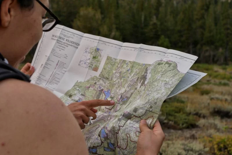
Why Paper Maps Still Matter in the Backcountry
Modern hikers rely heavily on smartphones for navigation. GPS apps are convenient, fast, and often surprisingly accurate. But batteries die, screens crack, storms interrupt signals, and cold weather drains power faster than most people expect. Every year in the United States, search and rescue teams respond to incidents involving hikers who became disoriented after losing access to digital navigation.
That is exactly why learning how to read a topographic map when your phone dies and you’re lost remains one of the most valuable outdoor skills a person can have. A printed map never needs charging. It does not depend on cell service. More importantly, it teaches you to understand the landscape instead of simply following a glowing dot on a screen.
Experienced backpackers often say that a map changes the way you see the wilderness. Instead of wandering through random terrain, you begin recognizing ridges, valleys, saddles, drainage systems, elevation changes, and natural travel corridors.
Many outdoor instructors now encourage beginners to carry both digital and analog navigation tools. Stores and outdoor specialists connected with Lanikai Camp often recommend waterproof topographic maps, durable compasses, and emergency backup kits for hikers exploring unfamiliar terrain.
Why Traditional Navigation Is Becoming Popular Again
There has been a noticeable shift among younger hikers and overlanders in recent years. Social media has popularized remote adventures, but it has also exposed how unprepared many people are once technology fails. Outdoor schools across Colorado, Washington, and Montana report increased enrollment in wilderness navigation courses.
People are realizing that survival skills are not outdated hobbies. They are practical forms of self-reliance.
Understanding Topographic Lines Without Confusion
The heart of every topographic map is the contour line. At first glance, these lines can look overwhelming. However, once you understand what they represent, the entire landscape starts making sense.
1. What Contour Lines Actually Mean
Contour lines connect points of equal elevation. Imagine slicing a mountain horizontally into layers. Every slice would create a line representing the same height above sea level.
Reading Line Spacing
The spacing between contour lines tells you how steep the terrain is:
- 1. Lines close together indicate steep slopes.
- 2. Lines spread apart indicate gentle terrain.
- 3. Extremely tight lines may represent cliffs or dangerous drop-offs.
This simple observation helps hikers avoid exhausting climbs or identify safer travel routes.
Recognizing Terrain Shapes
Contour lines also reveal landforms:
- 1. Circular patterns usually indicate hills or peaks.
- 2. V-shaped contours often point toward valleys and streams.
- 3. Saddle shapes show lower areas between two higher points.
One of the biggest breakthroughs for beginners happens when they stop seeing contour lines as random markings and start visualizing the terrain in three dimensions.
2. Understanding Elevation Intervals
Every map has a contour interval listed in its legend. This tells you how much elevation changes between contour lines. For example, a 40-foot contour interval means each line represents a 40-foot increase or decrease in elevation.
If you ignore contour intervals, it becomes easy to underestimate how difficult a route actually is.
Essential Symbols and Features You Need to Recognize
A topographic map contains far more than elevation data. It also includes important symbols that can guide survival decisions.
1. Water Sources
Streams, rivers, ponds, and springs are usually marked in blue. In survival situations, water sources can become critical reference points. Following a drainage downhill often increases the chance of reaching roads, campsites, or populated areas.
2. Man-Made Structures
Trails, roads, ranger stations, bridges, cabins, and power lines can all appear on a topographic map. Learning these symbols before entering the wilderness saves valuable time during emergencies.
3. Vegetation and Terrain Changes
Different shading patterns may indicate forests, marshes, rocky terrain, or open ground. Dense vegetation can dramatically slow travel speed, especially during poor weather conditions.
Experienced navigators study terrain in advance rather than reacting to obstacles after they appear.
How to Find Your Position When You Feel Completely Lost
Panic is the greatest enemy when someone realizes they are disoriented. The first step is always to stop moving long enough to analyze the situation carefully.
1. Use Terrain Association
Terrain association means comparing what you physically see around you with the shapes shown on the map.
Look for Distinctive Features
Ask yourself:
- 1. Is there a ridgeline nearby?
- 2. Are you standing beside a stream?
- 3. Do you see a mountain peak or lake?
- 4. Are you in a narrow valley?
Matching visible terrain with map features is often faster than relying solely on compass bearings.
Estimate Elevation
If you know approximately how high you climbed, contour lines can narrow your possible location dramatically.
2. Orient the Map Correctly
A map becomes much easier to interpret once it aligns with the real world. Rotate the map until north on the map matches actual north.
Many experienced hikers physically point the map toward visible landmarks while standing still. This reduces confusion and improves directional awareness.
3. Backtrack Carefully
If conditions are safe, retracing your steps may help you relocate a known trail intersection or landmark. However, random wandering usually makes situations worse.
Using a Compass Together With a Topographic Map
A compass transforms a map from a static reference into an active navigation system.
1. Understanding Basic Compass Functions
You do not need military-level navigation skills to use a compass effectively.
Key Compass Components
- 1. Magnetic needle points north.
- 2. Rotating bezel helps determine bearings.
- 3. Direction-of-travel arrow shows movement direction.
2. Taking a Bearing
If you can identify a mountain, lake, or ridge on your map, you can use a compass bearing to estimate your position.
This process is called triangulation when repeated with multiple landmarks.
3. Avoiding Magnetic Mistakes
Many beginners accidentally navigate using magnetic north instead of true north. Depending on your location in the United States, magnetic declination can create significant navigation errors over long distances.
Always check your map for local declination information before starting a route.
Terrain Association Skills That Can Save Your Life
Professional wilderness guides often rely more on terrain association than on precise compass bearings.
1. Handrails
Handrails are natural or man-made features that guide movement. Rivers, ridgelines, roads, and fences can all function as navigational handrails.
Instead of traveling through random wilderness, experienced hikers move alongside recognizable terrain features whenever possible.
2. Catch Features
A catch feature is a landmark that tells you when you have gone too far. For example, a highway, river, or cliff beyond your destination can prevent accidental overshooting.
3. Attack Points
An attack point is a clear landmark near your final destination. Navigators use it as a starting reference for the final portion of travel.
These techniques sound simple, but they dramatically reduce confusion in dense forests or mountainous environments.
A Real Survival Story That Changed Outdoor Training
One widely discussed wilderness incident involved a group of day hikers in California who relied entirely on smartphone navigation during a late autumn trek. Unexpected freezing temperatures drained multiple phone batteries simultaneously. As fog moved in, the hikers lost the trail and wandered for hours before emergency crews located them.
Search and rescue reports later noted that the group carried no printed map, no compass, and little understanding of terrain awareness.
Stories like this have reshaped modern outdoor education. Many survival instructors now teach that navigation redundancy is just as important as carrying food or water.
Experienced hikers often follow a simple rule: one navigation system is convenience, two systems are preparation.
Common Navigation Mistakes Hikers Make
1. Overconfidence With GPS Apps
Digital maps can create false confidence. Many users follow routes blindly without studying the terrain itself.
2. Ignoring Weather Conditions
Rain, snow, fog, and darkness can make familiar trails almost unrecognizable. Visibility changes dramatically affect navigation accuracy.
3. Failing to Check the Map Regularly
Good navigators constantly compare terrain with their map during travel. Waiting until you are already lost makes recovery much harder.
4. Moving Too Fast Under Stress
People often speed up when anxious. Unfortunately, rushed movement increases mistakes, exhaustion, and injury risk.
Building Confidence Before Your Next Adventure
The best way to learn topographic navigation is through practice before an emergency happens.
1. Start Small
Practice reading contour lines at local parks, state forests, or easy hiking trails. Compare what you see around you with what appears on the map.
2. Train With Real Conditions
Try navigating without GPS during short hikes. Learn how weather, shadows, and terrain affect orientation.
3. Carry Reliable Gear
A quality compass, waterproof map case, emergency whistle, and backup lighting system can make a huge difference outdoors. Many experienced campers use Lanikai Camp to discover dependable hiking gear, survival tools, and outdoor essentials suited for both beginners and advanced adventurers.
4. Learn Before You Need the Skill
The wilderness becomes far less intimidating once you understand how landscapes work. Reading a topographic map is not just about survival. It deepens awareness, builds confidence, and creates a stronger connection with the outdoors itself.
Technology is useful, but real navigation skill begins when you can still find your way after the battery icon disappears.


 Laku RV Campground4.0 (16 reviews)
 Cheboygan State Park Campground4.0 (17 reviews)
 Logan Valley Christian Retreat4.0 (51 reviews)
 River Landing Camp Ground4.0 (12 reviews)
 Campsite 227 (Full Hookup)0.0 (0 reviews)
 Lakeview Estates MHC3.0 (56 reviews)
 Why I Switched from a Tent to a Hammock for Appalachian Trail Section Hikes
 Camping with a Bad Back: Chairs, Mats, and Sleeping Solutions That Saved Me
 Three Times I Ignored Weather Warnings Camping – Tornado Watch Story
 20 Camping Hacks Using Dollar Store Items That Actually Work
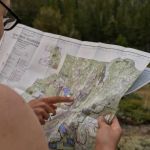 How to Read a Topographic Map When Your Phone Dies and You’re Lost
 Why Your $50 Sleeping Bag Feels Colder Than the Ground Outside – Real Camping Truth